Geography Resources
Alaska is a land of superlatives.
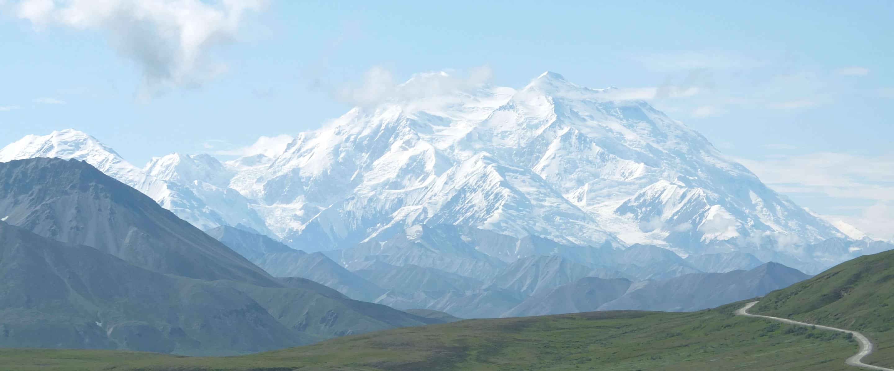
It has the highest peak in North America (Mt. McKinley, 20,320 feet) and 17 of the 20 highest mountains in the U.S. It has over 3,000 rivers, three million lakes, and five percent of its area is covered with permanently frozen water in the form of glaciers. Alaska has the largest expanse of tundra and boreal forest in the United States as well as the largest area of northern rainforest. It has more active volcanoes than any other region in the United States and it has experienced the largest earthquakes ever recorded in North America. Alaska’s 6,640 miles of coastline constitute approximately 54 percent of the U.S. total.
Understanding Alaska’s geography is vitally important to understanding the richness, reality, and responsibility inherent in this state.
We have developed two major learning tools, Alaska – A Land in Motion and Alaska in Maps – A Thematic Atlas. Both of which highlight the significance of geography in Alaska and encourage students of all ages to explore and understand the region. Through this, and our other Alaska Commons programs, the Institute of the North seeks to support new generations of informed Alaskans.
An Introduction to Alaskan Geography
By Roger Pearson, Senior Fellow, Institute of the North
Alaska is approximately 590,000 square miles in size. While larger than the next three states combined, Alaska’s size factor is matched by its shape. Its east-west extent of 2,400 miles reaches from 130 degrees W. near Hyder in Southeast to 172 degrees E. near Attu in the Aleutians. This is an area that would comparably extend from Columbia, South Carolina to Santa Barbara, California. Its latitudinal range of 20 degrees would stretch from the Canadian border to the Mexican border. This great latitudinal range, from 51 degrees N. to 71 degrees N. means that Alaska has a cool to cold climate. But, differences abound from Interior areas with great seasonal extremes and low precipitation, to southeastern coastal areas with moderate temperatures and high precipitation.
Alaska’s location in the world can be seen from three perspectives. First, it is part of the North Pacific Ocean region. The first peoples to occupy Alaska came from what is today the Russian Far East. In more recent times, the Russians occupied Alaska (“Russian America” from the mid 1700’s to 1867. Today peoples of the Russian Far East and Alaskans continue to maintain links with each other. Physically, Big Diomede Island (Russia) and Little Diomede Island (U.S.) are only a couple miles apart. Second, Alaska is also part of the North. It shares peoples, landscapes, and waters with northern Canada, Greenland, Iceland, the Scandinavian countries, and Russia. Third, Alaska is part of North America. Eskimo and Athabaskan-Tlingit language families were and are found on both sides of the Alaska-Canada border. Today, English dominates the region. Sometimes Alaska’s location with respect to the rest of the U.S. is distorted on maps—appearing west of Mexico or in place of Canada’s British Columbia. Not until World War II was it linked by road to the rest of North America.
Environmentally, Alaska is a land of superlatives. It has the highest peak in North America (Mt. McKinley, 20,320 feet) and 17 of the 20 highest mountains in the U.S. It has over 3,000 rivers, three million lakes, and five percent of its area is covered with permanently frozen water in the form of glaciers. Alaska has the largest expanse of tundra and boreal forest in the United States as well as the largest area of northern rainforest. It has more active volcanoes than any other region in the United States and it has experienced the largest earthquakes ever recorded in North America. Alaska’s 6,640 miles ofcoastline constitute approximately 54 percent of the U.S. total. (Its shoreline, the detailed crenulations of the coast total 33,904 miles.)
Alaska is a land of great economic resources, oil and gas, minerals, forests, and fish. It is also an area where few people live. With a population of approximately 700,000, its density is just over one person per square mile. This number is deceptive, of course. Nearly 75 percent of the state’s population lives along the “Railbelt” which makes up about 20 percent of the state. This region extends from the Kenai Peninsula Borough through the Municipality of Anchorage, the Matanuska-Susitna Borough and north to the Fairbanks North Star Borough. In contrast, one quarter of the population lives in the remaining 80 percent of the state. Note, however, that even the Railbelt region includes the essentially uninhabited conservation units of Kenai Fjords National Park, the Kenai National Wildlife Refuge, Chugach National Forest, and Denali National Park.
Like its physical geography, Alaska’s human geography is also highly diverse. Alaska’s Native population is divided into three major linguistic groups and 20 linguistic subgroups. Today’s urban Alaskans reflect the diverse population of the U.S. The municipality ofAnchorageis home to approximately 100 nationalities. This diversity should not be surprising given the global location of Alaska. Anchorage is a linkage point for air traffic between the U.S. and Asia and between Asia and Europe.
Finally, at the time of statehood, ninety-nine percent of Alaska’s lands were federally controlled, in effect, commonly owned. Today most of Alaska is still commonly owned—approximately 60 percent federal and 28 percent state controlled. Alaska Native corporations, regional and village, control another 12 percent of the land. Individual private land holdings constitute roughly one percent of land ownership. Thus, Alaska is an excellent setting for seeking an understanding of the commons.
K – 12 Curriculum Materials
Curriculum materials developed in part by the Institute of the North include:
Alaska in Maps – A Thematic Atlas
In contrast to a topographic-type atlas that emphasizes contour lines and selected settlement features, a thematic map offers maps of special topics. This includes maps which show earthquakes, volcanoes and Native language regions, for example. It was primarily designed for Alaskan middle and high school students, however, it can be a useful atlas for anyone who wants to know about the geography of Alaska.
To purchase Alaska in Maps – A Thematic Atlas or the Alaska in Maps CD-ROM version, please contact:
Todd Communications
611 E. 12th Avenue
Anchorage, Alaska 99501-4063
U.S.A.
Tel: 907.929.5500
Fax: 907.929.5552
To purchase the teacher’s guide, please contact:
Katie Kennedy
University of Alaska Geography Program
School of Natural Resources and Agricultural Sciences
PO Box755840
Fairbanks, AK 99775-5840
U.S.A.
Tel: 907.474.7494
Fax: 907.474.7484
Email: katie.kennedy@alaska.edu
Meeting of Frontiers
Teaching Units
The teaching units provided here are based on national standards in history, geography, and technology and include suggestions for assessment. They are designed to engage Alaskan high school students in the rich history and geography of the state. To download the PDF curriculums, simply click on the titles below.
Essays
This section includes three essays by Malcolm B. Roberts, a senior fellow at the Institute of the North. These essays explore the events on the Russian/American frontier of the 20th Century, how Alaska became an unusual mixture of Russian and American systems and traditions, and the remarkable and diverse history of indigenous peoples on both sides of what is now a common frontier.
- Essay 1: The first half of the 20th century on the eastern and western frontiers
- Essay 2: The frontiers meet and merge in Alaska
- Essay 3: Russian and Alaskan indigenous peoples on the 20th century frontiers
At the end of each essay, students are presented with guiding questions, projects, and reference materials.
In 1999, the Library of Congress launched the “Meeting of Frontiers” website. From a modest beginning, the site now contains thousands of documents not only from the Library of Congress but also from libraries in Russia, Germany, and Alaska. The web site catalogs the paralleling stories of America’s westward movement and Russia’s eastward movement to where they meet—in Alaska.